|
[Return to
Charter Page]
A VFR Flight Package
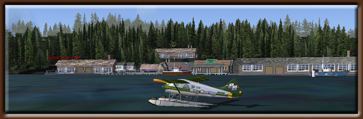
Misty Fjords - Hunter Bay Cannery
Charter

| |
Airfield |
ICAO Code |
Runway |
| Departures |
Ketchikan, AK
|
PAKT or 5KE or MMI1
|
At Ramp or Water Runway |
| Arrival |
Ketchikan, AK |
PAKT or 5KE or MMI1 |
per ATC |
|
Charter Notes
Note: This charter
package has been made exclusively to support the new
Misty Fjords Scenery (payware) package. It is NOT recommended
you fly these charters unless you have this package.
The directions, headings and FSNavigator plans are exact
for the Misty Fjords Scenery package which is more exact
than the standard scenery packages for FS2004.
The Charters: When
you take your first trip to Alaska, you will have an opportunity
to observe the bush planes, amphibians and float planes,
in action. One of the tasks of the bush pilots in this
area is to service not only the tourist interests for the
area but also to support the various commercial operations
located throughout the Ketchikan area. In the Ketchikan
and Misty Fjords area you will find commercial fishing
activities along with the supporting canneries. The goal
of each charter is not only to get you there and back safely,
but also show you some of the sites and through a "narrative" give
you historical and cultural information so you can learn
about this beautiful corner of our world. The VFR plans
will be in BOLD type and the narratives will be in italics.
Flying Direct and Treetop
VFR: If you are lucky enough to have a clear weather
day, you may use the "Direct" headings to and
from the cabins. These are set up for Mountain Point
as the start point (the point on the eastern side of
the south end of the Tongass Narrows). This allows you
to have sufficient altitude to commit to any heading
from that point. About 3500 feet is a safe altitude across
most of the Misty Fjords National Monument. However,
the flying in this charter package is set up with VFR
in mind, without the need for "electronic" waypoints.
This means you will have to acquire a knowledge for the
area, know what you are seeing and know how to reach
your destination especially under "misty" weather
conditions. We always recommend you download the latest
weather from the internet so you can make your charters
as 'real as it gets.' Do not be surprised that 8 out
of 10 downloads will give you weather that is nearly
unsuitable for VFR flying. That is why they call this
area of the world 'Misty Fjords.' Without electronic
waypoints, you are going to be flying under the low weather
ceilings and navigating by the visual waypoints you encounter,
often between mountains. A wrong turn can put you down
an inlet where there is no outlet and you'll find yourself
looking at the face of a mountain coming at you at 100
mph. If you do these charters realistically, you will
have some white knuckle moments. And that is the way
it really is.
FSNavigator4 and EZ-Landmark: Most of
the charters will have FSNavigator plan (.fsn) files included
for each charter. These will help you navigate to and from
the various commercial interests. Also included is a special
Misty Fjords EZ-Landmark database that adds over 400 waypoints
to the Misty Fjords area ... making VFR flying a pleasure
and very realistic. More information on both of these program
and how to interface them with the charters can be found
at Misty Moorings,
Inc. Maps will always be included that will help you
find your way through the beautiful Misty Fjords scenery.
Using this Document: You do not need
to read through this entire document. Use the index below
to choose the charter you would like to fly. Read through
it to see if it is the one you want. Then you can use the "Printer
Friendly" output to send the data to your printer. Text
in italics is "narration." This tells you
about the things you are seeing out your window, similar
to what an actual pilot might be telling a passenger. However,
if you do not care for the narration, then the actual VFR
directions are in bold.
|
|
|
|
Hunter Bay Cannery
Charter 
Minimum ceiling: 2000 feet
Minimum flying altitude: 1500 feet
Minimum visibility: 3 mile
Approximate distance: 40 miles
Landing Area NOT frozen in winter
Water landings year around
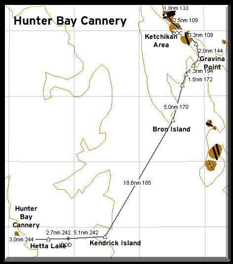
FSNavigator files [here]
Enlarged Map [here]
Printer-Friendly VFR Plan [here]
Direct from Gravina Point to Cannery: 33 miles at 199
Direct from Cannery to Gravina Point: 33 miles at 018
The Charter:
You just received a call from the Hunter Bay Cannery Manager.
He would like for you to pick up the new Assistant Manager
at the Ketchikan Airport and bring him to Hunter Bay. This
is the Assistant Manager's first trip to Alaska and to
the cannery. The Manager has asked if you would tell him
a little about some of the sights along the way and fly
a more scenic rather than direct flight to the cannery.
He knows the new man loves the outdoors and wants to impress
him with the beauty of Alaska. So you have two assignments,
(1) fly your passenger safely from Ketchikan to Hunter
Bay, and (2) sell Alaska to the new Assistant Manager.
The VFR directions are bold and the narrative for
your passenger is in italics. The VFR directions
for your return to Ketchikan are also included.
VFR Directions: Flying to the Hunter Bay Cannery
- After leaving PAKT or 5KE, position over the center
Pennock Island in the Tongass Narrows at a heading
of 110
- We will be leaving Ketchikan International and
heading southeast down the Tongass Channel. This
body of water separates Gravina Island to our right
(where the airport is located) and Revillagigedo
Island to our left where Ketchikan is located.
In the center of the channel is Pennock Island.
- In 1883, a man named Snow built a salmon saltery
on the spot where Ketchikan now stands. Two years
later, businessmen from Portland, Oregon, hired
Mike Martin to investigate possibilities for building
a salmon cannery on the banks of Ketchikan Creek.
Martin and the cannery's manager, George Clark,
set up a partnership and opened a saltery and a
general store. Two years later, with the fishing
trade flourishing, Ketchikan was definitely in
business.
- And by 1900, with a population of 800, the town
was officially incorporated. With mining activities
beginning in the area, Ketchikan became an important
trading community, with an estimated two-thirds
of miners' wages reportedly ending up in the bars
and bordellos of Creek Street. Despite a mining
decline, the fishing industry and timber operations
began to grow with establishment of the Ketchikan
Spruce Mills early in the century.
- In 1954, Ketchikan Pulp Mill was completed at
nearby Ward Cove, assuring jobs not only in town,
but in the surrounding woods as well. Wards cove
is behind us on the left. The mill is not running
today. The lumber industry is in trouble world
wide but the ever resilient Alaskans are starting
to focus on another mainstay, tourism. Cruise ships,
the Alaska Marine Highway and Alaska Airlines as
well as many charter operators bring thousands
of visitors to town through the summer months,
while across Tongass Narrows, an endless stream
of jet aircraft keep Ketchikan very much in touch
with the world outside.
- At the midpoint of Pennock Island, set a heading
of 141 to Gravina Point. This is the point of land
at the southern most tip of Gravina Island (the large
island on your right), about 2.9 miles distant. Prepare
for a course correction to starboard.
- The large channel ahead of us before we make
this turn to the right is Revillagigedo channel.
On the left is Mountain Point, and around the point
to the left is Herring Bay where there is another
cannery and fishing village.
- The Island ahead of us about 1 o'clock is Annette
Island. The large mountain is Red Mountain with
the tiny settlement of China Town at the foot of
the mountain beside the sea.
- At Gravina Point, set a heading of 194 for 3 miles
to fly over Blank Island.
- As we make the turn to the right over Gravina
Point, we are turning into the Nichols Passage.
- The small mountain to our right is Judy Hill
and if you look back up the Tongass Channel, you'll
still be able to see the Ketchikan airport.
- This first inlet to our right is
Blank Inlet. At its mouth is Blank Island, our next
waypoint. This inlet is known for it's wonderful
sports fishing for salmon. Many people who come in
on the cruise ships will charter a boat from Ketchikan
and come to this inlet to fish.
- We'll be flying down the southern
coast of Gravina Island (the landmass to starboard)
using various points of land as waypoints.
- Over Blank Island, set a heading
of 196 heading for Bostwick Point ... the point just
ahead.
- Bostwick Inlet, coming up on our starboard side
is another sports fisherman haven. On the other side
of this inlet, the point of land is Bostwick Point.
We'll be flying over that toward Seal Cove.
- Over Bostwick Point, we set
a course of 170 for the Bron Island, fly to its center.
- We will pass over a little cove
called Seal Cove, then head down toward the southern
tip of Gravina Island. This is called Dall Head.
Bron Island is the larger island showing up at the
head of Dall Bay (the bay just before the Dall Head).
- On Dall Head, there is a
very interesting Dall Head Marine Park that you
should try to see if you have the time.
- Exactly over the center of Bron Island, set a course
of 185. This course will take you to the mouth of Kendrick
Bay, 18.5 miles ahead. In the mouth of the bay is the
large Kendrick Island. You will want to fly over the
center of Kendrick Island.
- This small group of islands we are
crossing are called the Bronaugh Islands. The Dall
Head is just to our right.
- As we cross the body of water ahead of us, the
Clarence Straight is to our right. This is the body
of water separating Gravina Island from Prince of
Wales Island, ahead of us.
- The climate is temperate and is influenced by
the Japanese current and gives Prince of Wales Island
between 60 and 200 inches of precipitation per year.
Mean temperatures range from around 35 degrees; in
January to about 58 degrees; in July. Daylight on
the longest day of the year is about 15½ hours
with about 7 hours on the shortest day of the year.
- Most of the island is characterized by steep,
forested mountains (2,000-3,000 feet high) carved
by glacial ice which left deep U-shaped valleys with
streams, lakes, saltwater straits and bays. The forest
is made up of Sitka spruce and western hemlock with
some western red and yellow cedar, alder, and shore
pine.
- Sitka black tailed deer and black bear are the
primary game animals, and the island supports several
packs of wolves. Moose have been spotted on Prince
of Wales. While the streams and lakes contain a variety
of trout, most people fish the salt water for the
five species of salmon, or for halibut, red snapper,
and other bottom fish. Eagles are a common sight
and waterfowl abound during the nesting season. Several
species spend the winter in the area including the
trumpeter swan. (see
note 2)
- Over Kendrick Island,
set a heading of 242. You will be flying over the bay
and over the body of land ahead. As you begin to reach
the west coast of the island, begin your descent. Pass
to the left of Hessa Lake. You will be landing just
after the ridge ahead of you. You will see a small
round lake with a river leading away from it to the
west. That river empties into Hunter Bay. Follow the
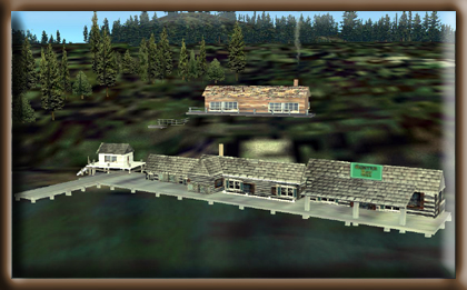
river to Hunter Bay. The cannery is on the right of
the bay. NOTE: Beware of fishing vessels often parked
in the bay.
- We are now nearing Hunter Bay
which is directly ahead of us on the other side
of the island. We will now be reducing altitude
for our landing in front of the cannery on Hunter
Bay.
- Landing
in Hunter Bay
- After you have landed safely, taxi to the cannery's
dock and unload your passenger. (Be sure to give
him your business card so he contacts you for his
next charter!)
VFR Directions: Returning to Ketchikan
- Taxi out and take off lining up with
a heading of 063. Hessa Lake will come up on the port side
of the aircraft. Continue for 6.5 miles until you are over
Kendrick Island.
- Over Kendrick Island, set a heading
for 005. Maintain this course for 18.5 miles to Bron Island.
- As you pass by Dall Head and cross
over Bron Island, set a heading for 355 and fly along the
south coast of Gravina Island. On the way passing Seal
Cove, Bostwick Point and heading for Gravina Point. If
the weather is clear, you may cut across land to the left
of Judy Hill and shortcut to the Tongass Channel. Watch
for air traffic for PAKT in this area.
Back to Top
|
|
|