|
Route Notes:
- Minimum altitude: 2000 ... suggested 1000 until you reach the
landing zone where you must be at 1650 minimum feet.
- Direct Routing: If the weather is favorable, you may fly a direc
heading from Vallenar Point of 218 for 26 miles.
- Landing zone: water only, freezes in winter
- You should have the Summit Lake Lodge Scenery Addon from Misty
Moorings
- NOTE: Read the "landing" carefully, it is a little
tricky.
- Click [here] for printer-friendly
TripTic
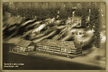
Summit Lake Lodge
The lodge is on a remote corner of beautiful Summit Lake. It comes
complete with lodging quarter, a bait and tackle shop and a cabin
with bear and lake observation deck.
TreeTop VFR Plan
From: Ketchikan International
To: Summit Lake Lodge
1. Fly a heading of about 295 northwest up the center of the
Tongass Narrows to Vallenar Point.
...you will see ward cove off starboard, with the paper mill
...the furthest point of land to port is Vallenar Point, the northwest
end of Gravina Island.
... as you approach Vallenar Point, the little islands just off
the coast are called the Guard Islands.
... About 1 o'clock at 3 miles is the Guard Lighthouse.
2. Over Vallenar Point, set a heading of 195 for the entrance
of Cholamandelay Sound, on Prince Edward Island, 10.4 miles ahead.
... As we approach the entrance to Cholamandelay Sound, you will
pass small Skin Island that will be off to starboard.
... when Skin Island is at 3 o'clock, and Chasina Point is at your
9 o'clock, you are at our VFR waypoint.
3.At the entrance of Cholamandelay Sound, turn to 185 for small
Hump Island in the center of the sound (4 miles).
... Dora Bay is at 11 o'clock
... We will be turning to starboard to head for the West Arm of
the Chalamandelay Sound.
4. At Hump Island, set a heading of 256 heading for the northern
shore of Divide Head.
... as you approach the Divide Head, you will see Skinney Cove on
the starboard side of the sound.
... right ahead is the entrance to the West Arm, we will be flying
up the West Arm.
5. As you pass the Divide Head to port, you will see the West
Arm straight ahead ... adjust to fly to the end of the arm.
... to port is the South Arm and to Starboard is Sunny Cove.
... stay to the center of the curving West Arm
NOTE: When you see the small islands in the center of the West
Arm begin Increasing altitude to 1650 feet! (you will be making
a turn to port flying between some mountains.
6. At the end of the Arm, turn to port to an approximate heading
of 222 and follow a gap between the mountains to a ridge.
... Round the mountain to port and fly toward the gap straight ahead.
... the gaps begins to end but turns to port, follow that direction
and you will begin to see Summit Lake. That is your landing zone!
... if you miss the landing zone, turn to starboard to travel down
the length of the lake, land and taxi back.
... the Summit Lake Lodge is on the shore of the lake you cross
as you fly over the boundary of Summit Lake.
=============================================================
To Return Direct: Fly 039 for 26 miles to Vallenar Point.
Doug Linn
Charter Manager
Misty Moorings, Inc
contact@mistymoorings.com
|