|
Route Notes:
- Minimum altitude: no minimum ... suggested 1000 feet.
- Direct Routing: If the weather is favorable, from Mountain Point
fly 357 for 34 miles.
- Landing zone: water and hard runway, water freezes in winter
- Spotted Lake Retreat scenery needed from Misty Moorings
- Click [here] for printer-friendly
TripTic
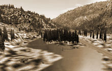
Spotted Lake Retreat
Complete with runway on small "Spotted Lake" nestled
among the mountains off the Behm Canal at N55 49.53 W131 08.70.
Has bear viewing and safe storage stand, dock for the floatplane
and extra fuel. Lovely cabin with fire in the fireplace. Tent camping
available. Wildlife seen in the immediate area. Fly about 5 miles
north of the outfall of the Chickamin River on the Behm Canal. The
lake is located about 2 miles inland. A misting rapids tumbling
into the Behm Canal is your clue to turn inland!
TreeTop VFR Plan
From: Ketchikan International
To: Spotted Lake Retreat
1. Fly a heading of 100 down the Tongass Narrows toward Pennock
Island
...Fly over the center of Pennock Island
...watch for the cruise ships on left and the Clione vessel plying
the narrows.
...You'll pass Ketchikan on your left and see Saxman coming up on
your left as you fly over Pennock Island.
...Coming up on your right is Gravina Point.
2. Over Pennock Island, set a heading of 095 shooting the gap
between Mountain point on your left and Race Point on your right.
...You are now heading directly for Bold Island
...As we fly, you will be passing the entrance to the the Carol Inlet
on your left, it winds up behind Ketchikan, but is eventually a
dead end.
...Small Spire Island comes up to starboard
...Just past Spire Island the point of land is Reef Point. You should
be heading for the center of Bold Island, just ahead.
3. Over Bold Island, maintain a course of 095, you are
heading for Alava Point about 8 miles ahead.
...look closely and you will see the small Antellope Trail Ranch down
to your left there in Coho Cove.
...To our left is the inlet to the Thorne Arm.
...You are flying down the Revillagigedo Channel ( the gateway to
Alaska from the south). Wach for cruise ships in this area.
...Continue to Alava Point, we will be rounding it to the left starting
to fly up the Behm Canal.
4. Once you have just cleared the point, make a left turn
to 010 setting a visual heading for the left shore far in the distance
...We are getting ready to fly over Alava Bay, look closely at the
large island and you may see the Alava Bay Cabin
...The first point you encounter after Alava Bay is Ape Point
...The next point justting into the Behm Canal from the left shore
is Fox Point ... head to fly over Fox Point.
...continuing on this heading (095) you will see Rudyerd Island coming
up, visually head to fly over it.
...just beyond Rudyerd Island is Smeaton Island. Head for the center
of Smeaton Island, maintain minimum of 1200 feet.
...off to the right of Smeaton Island you'll see Smeaton Bay on the
starboard side of the canal.
... the leading edge of Smeaton Island is called Harris point ...
recheck your altitude for minimum 1200.
5. As you reach the far shore of Smeaton Island, make
a heading correction, turn left to 335 over Eddystone Rock.
...the northern point of Smeaton Island should come under your port
wing, that is Harding Point.
...off to starboard (your right) you will see little Candle Island,
then just beyond it the beautiful Winstanley Island
...there are two cabins on Winstanley Island.
... you may want to drop down to 300 feet to get a good look at
Eddystone Rock, a strange rock structure in the center of the Behm
Canal.
6. Over Eddystone Rock, continue heading of 335 flying toward
Manzanita Island, 4 miles ahead.
...You will see it appearing like a penninsula from the port side
of the Behm Canal.
7. Over Manzinita Island, set a heading of 320 following the
port shoreline toward Snip Island.
... don't get too close in foggy weather as there are mountains
near the shore.
... you will pass over tiny Snip Island.
8. Over little Snip Island, come slightly left (about 310) following
the left shoreline watching for a misting outfall of a river.
... reduce altitude to 1000 feet
... You will see a small inlet called Portage cove on the left shore
in about 3 miles... fly just off the shoreline
... The inlet to the Chickamin River will pass on the starboard
side of the canal.
... you will see a river coming out from between the mountains about
11 o'clock, with mist coming from a waterfall, this is where you
will make a sharp turn to port.
9. At the misting waterfall, turn to port to follow the curving
little river to its outfall on Spotted Lake.
... following the river will line you up on the runway at the Spotted
Lake Retreat.
To Return to Ketchikan, Reverse the above Route.
Doug Linn
Charter Manager
Misty Moorings, Inc
contact@mistymoorings.com
|