|
Route Notes:
- Minimum altitude: The landing zone is 2165 feet in altitude,
fly any minimum until 5 miles from landing zone.
- Direct Routing: If the weather is favorable, you may fly a heading
from Mountain Point 048 for 46 miles.
- Landing zone: water, can freeze in winter
- Need Raptor's Roost addon scenery from Misty Moorings, Inc.
- Click [here] for printer-friendly
TripTic
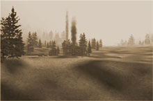
Raptor's Roost
A misty hideaway slipped into the scenery at (what we are naming)
Raptor Lake located at N55° 30.39, W130 12.41 at 2165 feet.
This is west of Alice Arm close to the Alaskan border on the Portland
Canal. The area is very isolated and the only inhabitants are campers,
hikers, and mountain goats.
TreeTop VFR Plan
From: Ketchikan International
To: Raptor's Roost
1. Leaving Ketchikan Int'l (PAKT) head southeast down the Tongass
Narrows centering over Pennock Island.
- Notice the cruise ships off the port wing at the wharf in Ketchikan.
- Notice the wind generator on Pennock Island.
2. Over Pennock Island, set a heading of 096 for Bold Island.
- The point of land to starboard is Gravina point.
- The last point of land on the port side of the Tongass Narrows
is Mountain Point ... a key waypoint for the area.
- The body of water to port will be the Carol Inlet, it is a dead
end, about 20 miles in length.
3. Over Bold Island, set a heading of 120 for Ham Island.
- Fly to the port side of Ham Island
- Tiny Lewis Island will pass slightly to starboard
- Slightly larger Walker Island passes to port
4. At the edge of Ham Island, turn left to 100 heading for the
Mary Lighthouse on the north end of Mary Island.
- Try to flight directly over the lighthouse.
5. Over Mary Lighthouse, set a heading of 110 for Kirk Point.
- Kirk Point is 8 miles ahead.
- There are two large mountains about 10 and 11 o'clock. These are
North and South Quadra Mountains, respectively. They guard the mouth
of the Boca de Quadra Inlet.
- The tiny group of islands just off shore from North Quadra Mountain
are the State Islands.
- Kirk point will show up as a finger of land coming out left to
right from the shore, set your heading to fly over the tip of it
6. Over Kirk Point, turn right to 140 heading for Foggy Point.
- Kirk Point is 4 miles ahead
- You will cross directly over the DeLong Islands group
- As you cross the islands, Foggy Bay is the bay at 9 o'clock.
- There is a marine navigational beacon on Foggy Point
7. Over Foggy Point, turn right slightly to 144 for Tree Point
Lighthouse, 7 miles ahead. Basically, you are following the shoreline.
- Watch for the Tree Point Lighthouse, and when you see it, correct
your heading to fly over it.
8. Over the Tree Point Lighthouse, turn left to 098 following
the shoreline toward Cape Fox and little Fox Island, 6 miles ahead.
- As you near Cape Fox, the shoreline travels off to your port.
Look for the small island off the cape, this is Fox Island, use
this for your waypoint and center over Fox Island.
7. Over Fox Island, turn left to 095, heading for the south
side of Kanagunut Island, approximately 5 miles ahead.
- The point at the south end of Kanagunut Island is Garnet Point,
position yourself to fly over Garnet Point.
8. Over Garnet Point, turn left to 084 heading for the Boston
Islands 4 miles ahead.
- The Boston Islands are a small group of islands about 1/2 mile
off the coast.
- The Point coming up to port is Wales Point (5 miles).
9. Over the Boston Islands, turn left to 070 passing over Tracey
Island only 2 miles ahead. Center over Tracey Island.
10. Over Tracey Island, turn left to 044 crossing over the tip
of Wales Point (just ahead)
*** DANGER: there is a large peak to the left of Wales Point stay
close to the water.
- cross over Wales Point heading for Truro Island straight ahead
five miles.
- You are flying up the Portland Inlet
11. You have turned into the Portland Inlet, you will connect
to the Portland canal. You will be flying about 50 nautical miles
on this leg.
... Here are some of the landmarks along the way
... Truro Island will be on the starboard shore and behind it, you
will see the larger Sommerville Island.
... You will see the inlet to the Wales Passage to port.
... Pearse Island is the large island along your port side.
... Coming up to starboard at the end of Sommerville Island is Start
Point (rounding start point, you would find Misty Lumber Company
up the Kwinamass River behind Start Point to starboard.
... the point to port is Pirate Point.
... at 1 o'clock you will see the Nasoga Gulf and on its port entrance,
Trefusis Point defining the end of the Milor Peninsula (all to port).
... stay to the left of Trefusis Point and move to the left side
of the inlet.
... ahead you will encounter a "Y" in the inlet ...
you will take the port branch which is the Portland Canal (the branch
to starboard is Observation Inlet).
... This short "pass" is Gwent Bay ... about 3 miles ahead,
you will turn to starboard up the Portland Canal.
... You will pass the Gwent Bay seaplane base to Port, the next
point to port is Tree Point.
... Across the bay from Tree Point is Dogfish Bay.
... Turn to starboard up the Portland Canal
... Look for tiny Reef Island (with two marine navigational markers
near the port shore.
... about two miles to port, just beyond the first ridge is Reef
Lake, a lake known for deep lake fishing.
... The tiny Sandfly Bay will come up to port about 2 miles ahead.
... Halibut Bay will come up in about 5 miles to port, this is an
inlet in the port shore that is about 3 miles long.
... You are flying a heading of about 010, look ahead and you will
see the Portland Canal turns to port to about 313
...You will see an island ahead with navigational markers make your
turn to port just before you reach the little island.
... The river entering the Portland Canal from the port shore is
the Cascade River.
... Little Tombstone bay comes up to port and Maple Bay will be
about 2 o'clock to starboard .. these are very small bays.
BEGIN INCREASING ALTITUDE TO 2200 feet!
... Begin watching for a small red boat pulling a barge.
12. At the Red Boat with the barge, be ready to make a sharp
turn to port to 244
... you will fly up a valley toward the lake at 2100 feet
... You will see two "misting and cascading rapids" up
the valley, fly over them.
... The lake will come into view as you pass over the waterfalls.
13 Land on the lake, the Raptor's Roost is at the far end of
the lake.
Direct Routing Back to Ketchikan: 46 Miles at a heading of 228
will get you to Mountain Point.
Doug Linn
Charter Manager
Misty Moorings, Inc.
contact@mistymoorings.com
|