Route Notes:

  • Minimum altitude: no minimum ... suggested 1000 feet.
  • Direct Routing: If the weather is favorable, you may fly a heading from Mountain Point 099 for 57 miles.
  • Landing zone: water, freezes in winter
  • Need "Misty Lumber"scenery from Misty Moorings
  • Click [here] for printer-friendly TripTic

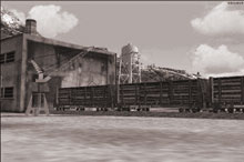
The Misty Lumber Company

The Misty Lumber Company is located North of Prince Rupert in the Misty Fjords. The company processes raw logs and produces construction grade lumber. The Lumber Company also has a Railroad spur to receive railroad cars that are barged up to the mill from the Logging sites.

TreeTop VFR Plan

From: Ketchikan International
To: Misty Lumber Company

1. Leaving Ketchikan Int'l (PAKT) head southeast down the Tongass Narrows centering over Pennock Island.
- Notice the cruise ships off the port wing at the wharf in Ketchikan.
- Notice the wind generator on Pennock Island.

2. Over Pennock Island, set a heading of 096 for Bold Island.
- The point of land to starboard is Gravina point.
- The last point of land on the port side of the Tongass Narrows is Mountain Point ... a key waypoint for the area.
- The body of water to port will be the Carol Inlet, it is a dead end, about 20 miles in length.

3. Over Bold Island, set a heading of 120 for Ham Island.
- Fly to the port side of Ham Island
- Tiny Lewis Island will pass slightly to starboard
- Slightly larger Walker Island passes to port

4. At the edge of Ham Island, turn left to 100 heading for the Mary Lighthouse on the north end of Mary Island.
- Try to flight directly over the lighthouse.

5. Over Mary Lighthouse, set a heading of 110 for Kirk Point.
- Kirk Point is 8 miles ahead.
- There are two large mountains about 10 and 11 o'clock. These are North and South Quadra Mountains, respectively. They guard the mouth of the Boca de Quadra Inlet.
- The tiny group of islands just off shore from North Quadra Mountain are the State Islands.
- Kirk point will show up as a finger of land coming out left to right from the shore, set your heading to fly over the tip of it

6. Over Kirk Point, turn right to 140 heading for Foggy Point.
- Kirk Point is 4 miles ahead
- You will cross directly over the DeLong Islands group
- As you cross the islands, Foggy Bay is the bay at 9 o'clock.
- There is a marine navigational beacon on Foggy Point

7. Over Foggy Point, turn right slightly to 144 for Tree Point Lighthouse, 7 miles ahead. Basically, you are following the shoreline.
- Watch for the Tree Point Lighthouse, and when you see it, correct your heading to fly over it.

8. Over the Tree Point Lighthouse, turn left to 098 following the shoreline toward Cape Fox and little Fox Island, 6 miles ahead.
- As you near Cape Fox, the shorline travels off to your port. Look for the small island off the cape, this is Fox Island, use this for your waypoint and center over Fox Island.

7. Over Fox Island, turn left to 095, heading for the south side of Kanagunut Island, approximately 5 miles ahead.
- The point at the south end of Kanagunut Island is Garnet Point, position yourself to fly over Garnet Point.

8. Over Garnet Point, turn left to 084 heading for the Boston Islands 4 miles ahead.
- The Boston Islands are a small group of islands about 1/2 mile off the coast.
- The Point coming up to port is Wales Point (5 miles).

9. Over the Boston Islands, turn left to 070 passing over Tracey Island only 2 miles ahead. Center over Tracey Island.

10. Over Tracey Island, turn left to 044 crossing over the tip of Wales Point (just ahead)
*** DANGER: there is a large peak to the left of Wales Point stay close to the water.
- cross over Wales Point heading for Truro Island straight ahead five miles.
- You are flying up the Portland Inlet.
- Fly to the left of Truro Island along the shore.

11. At the end of Truro Island, come left to a heading of 025 heading for Start Point, the point of land 6 miles ahead jutting out from the shorline on your right.
- Start Point is actually the northeast tip of Summerville Island, the large island passing to starboard.
- Fly up the shoreline of Summerville Island to the point.

Note: as you near Start Point ... you are going to round Start Point to the right, going around the tip of Summerville Island. Be ready to come to a heading of 108.

12. At Start Point turn hard to right to 108.
- You will be heading into the mouth of the Kwinamass River.
- Follow the river for 5 miles.
- The Misty Lumber Company is on the north shore of the river.

LANDING ... the river curves slightly to the left, come down to landing position as you enter the mouth of the river. Ahead the river narrows and you will see two islands. Plan to land just past the second island (the one to the right). The Misty Lumber Company is on the left shore.

To return to Ketchikan, reverse this route.

Doug Linn
Charter Manager
Misty Moorings, Inc
contact@mistymoorings.com

If you have any questions or comments, you can contact me at contact@mistymoorings.com

©2005 mistymoorings.com